


Download VIGps 1.0
|
Author: Valeri Vlassov
Support OS: WinME, Windows2000, WinXP, Windows2003
File size: 3.58 Mb
Price: 9.5$
Languages: English
Release date: 2005-12-24
Published: 2005-12-28
Support OS: WinME, Windows2000, WinXP, Windows2003
File size: 3.58 Mb
Price: 9.5$
Languages: English
Release date: 2005-12-24
Published: 2005-12-28
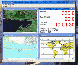
GPS Navigator with using a scanned maps and possibility to open a lot of maps together.
- you can show a current GPS data (Speed, Direction, Longitude, Latitude, Time, Date, Height);
- you can open any of scanned maps (in a "bmp" or "dib" format);
- you can calibrate the scanned maps yourself by two calibration points only (left-top and right-bottom);
- calibrations are stored automatically for every map, you do not need to calibrate a map next time;
- you can see your route line and speed direction at the map;
How to use it:
- connect your GPS device to your computer by the com-port;
- open a Properties Dialog and set you comport's name and a Bits Rate (for example: COM1, 4800);
- you will see your position point at the World Map.
- open any scanned map file in a bmp or dib format;
- point by mouse to the left-top point at the map, where you know the coordinats of that point (where coordinate lines are crossed, or where you have measured a coordinates yourself by your GPS device);
- press a right mouse button and input coordinates for that point;
- make the same for a right-bottom point anywhere at the map;
- now your scanned map is calibrated and you will see your position, speed direction and route line at it;
- menu "View / Clear calibration Points" for new calibration of a current map;
- use a button "Show Route Line" for siwtch on/off of showing a Route Line;
- use a button "Show GPS Data" for open a GPS Data window;
Hints:
- you can open a lot of scanned maps, GPS Data, World Maps together;
- default settings for comport: COM1, bits per second: 4800, data bits: 8, parity: none, stop bits: 1, flow control: hardware;
- use Property Dialog for setting a comport (Name and Bits per second) and refresh time for active map;
- maximize a GPS Data window to show a speed and direction as a big symbols (when you are sailing);
LIMITATIONS FOR DEMO-VERSION: No Position, Speed direction and Route lines at scanned maps.
download
Download free version
Download free version
buy
Buy full version
Buy full version
Related Software
|
We recommend: Able Graphic Manager 2.4.9.8

more info |
GPSLite for Windows Mobile 5.0 1.0.26.2007 by Codehero
2007-07-29
GPSLite is an easy, efficient and powerful positioning tool for mobile devices, you can get the Latitude, Longitude, Altitude , Speed, Local time, Local Date , Number of satellites being tracked, status of the GPS receiver etc...
TRANSDAT (Deutsch) 13.39 by C. Killet Software Ing.-GbR
2010-09-01
TRANSDAT Coordinate Conversion supports thousands of coordinate systems and geodetic datum shifts, user-defined systems, INSPIRE, NTv2, BeTA2007, GPS, continental drift, many file systems, ESRI-Shape and much more with highest accuracy.
TRANSDAT (English) 13.39 by C. Killet Software Ing.-GbR
2010-08-30
TRANSDAT Coordinate Conversion supports thousands of coordinate systems and geodetic datum shifts, user-defined systems, INSPIRE, NTv2, BeTA2007, GPS, continental drift, many file systems, ESRI-Shape and much more with highest accuracy.
Icons-Land Vista Style GIS/GPS/MAP Icon Set 2.0 by Icons-Land
2012-11-22
Vista Style GIS/GPS/Map Icon Set is of perfect design quality. Being represented in 7 sizes, icons can be widely used in local service applications, GPS tracking and GIS applications, and any kind of mapping applications.
SmartComGPS for Series 60 1.02 by SmartCom Ltd GPS Mobile Solutions
2005-11-04
New GPS mapping/tracking/navigation software for Symbian smartphones. It is one of most advanced GPS mapping software on the market. It is compatible with external BT GPS receivers, and internal aGPS receiver of Motorola A920/925/1000.
SmartComGPS for Series 90 media phones 1.02 by SmartCom Ltd GPS Mobile Solutions
2005-11-04
New GPS mapping/tracking/navigation software for Symbian smartphones. It is one of most advanced GPS mapping software on the market. It is compatible with external BT GPS receivers, and internal aGPS receiver of Motorola A920/925/1000.
SmartComGPS for Series 80 communicator 1.02 by SmartCom Ltd GPS Mobile Solutions
2005-11-04
New GPS mapping/tracking/navigation software for Symbian smartphones. It is one of most advanced GPS mapping software on the market. It is compatible with external BT GPS receivers, and internal aGPS receiver of Motorola A920/925/1000.
SmartComGPS for UIQ 1.02 by SmartCom Ltd GPS Mobile Solutions
2005-11-04
New GPS mapping/tracking/navigation software for Symbian smartphones. It is one of most advanced GPS mapping software on the market. It is compatible with external BT GPS receivers, and internal aGPS receiver of Motorola A920/925/1000.
Able DXF Manager 2.1 by GraphicRegion.com
2005-10-27
View, acquire, convert and print DXF files in normal, batch and command line modes. Input formats: DXF, TIF, JPG, PCX, BMP, DIB, RLE, PNG, WMF, EMF, TGA, VDA, ICB, VST, PIX, PXM, PPM, PGM, ICO, CUR. Output: JPG, TIF, PCX, PNG, BMP, TGA, PXM, PPM.